
Make a donation
Castile and León topographic map
Click on the map to display elevation.
Make a donation
Castile and León
The morphology of Castile and León consists, for the most part, of the northern half of the Meseta Central (Meseta Norte) and a belt of mountainous reliefs. The Meseta Central is a high plateau with an average altitude close to 800 m (2,600 ft) above sea-level; it is covered by deposited clay materials that have given rise to a dry and arid landscape.
Make a donation
About this map
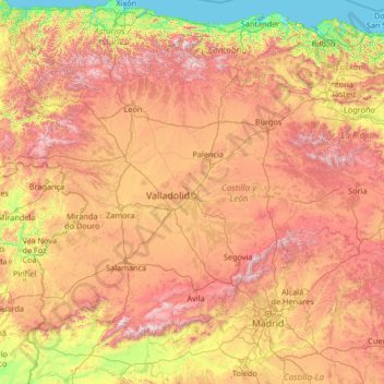
Name: Castile and León topographic map, elevation, terrain.
Location: Castile and León, Spain (40.08245 -7.07707 43.23820 -1.77537)
Average elevation: 770 m
Minimum elevation: -1 m
Maximum elevation: 2,468 m
Make a donation
Other topographic maps
Click on a map to view its topography, its elevation and its terrain.
Make a donation
Las Rozas / Les Roces
Spain > Cangas de Onís > Cangas de Onís / Cangues d'Onís > Las Rozas / Les Roces
Average elevation: 155 m
Make a donation