
Thank you for supporting this site ❤️
Make a donation
Make a donation
Lacs topographic map
Click on the map to display elevation.
Thank you for supporting this site ❤️
Make a donation
Make a donation
About this map
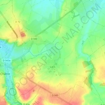
Name: Lacs topographic map, elevation, terrain.
Average elevation: 224 m
Minimum elevation: 196 m
Maximum elevation: 265 m
Thank you for supporting this site ❤️
Make a donation
Make a donation
Other topographic maps
Click on a map to view its topography, its elevation and its terrain.
²Le Grand Champ
France > Centre-Val de Loire > Indre > Lourouer-Saint-Laurent
Average elevation: 207 m
Thank you for supporting this site ❤️
Make a donation
Make a donation
Pièce de la Fosse aux Joncs
France > Centre-Val de Loire > Indre > Saint-Maur
Average elevation: 161 m
Thank you for supporting this site ❤️
Make a donation
Make a donation
Pièce du Bois et des Fosses
France > Centre-Val de Loire > Indre > Saint-Maur
Average elevation: 162 m
Thank you for supporting this site ❤️
Make a donation
Make a donation