
Make a donation
Hunterdon County topographic map
Click on the map to display elevation.
Make a donation
Hunterdon County
Much of the county is hilly, with several hills rising to 1,000 feet (300 m) in elevation. The highest points are two areas in Lebanon Township, one on the Morris County line, both reaching approximately 1,060 feet (320 m) above sea level. The first is at Smith on the Morris County line and the second is north of the area called Little Brook. This area is known as the Highlands of New Jersey. The lowest elevation is where the Mercer County line reaches the Delaware River, approximately 50 feet (15 m) above sea level. The county is drained by the Musconetcong River in the north. The river flows in a southwest direction. The Lamington River drains the county in the east. The central portion of the county is drained by the South Branch of the Raritan River. The Delaware River drains the western side of the county.
Make a donation
About this map
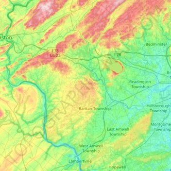
Name: Hunterdon County topographic map, elevation, terrain.
Location: Hunterdon County, New Jersey, United States (40.33943 -75.19554 40.78909 -74.70369)
Average elevation: 120 m
Minimum elevation: 10 m
Maximum elevation: 384 m
Make a donation
Other topographic maps
Click on a map to view its topography, its elevation and its terrain.
Basking Ridge
United States > New Jersey > Somerset County > Bernards Township
Average elevation: 98 m
Croxton
United States > New Jersey > Hudson County > Jersey City > Journal Square
Average elevation: 16 m
Make a donation
Charleston East
United States > New Jersey > Camden County > Cherry Hill Township
Average elevation: 23 m
Homes Mills
United States > New Jersey > Monmouth County > Upper Freehold Township
Average elevation: 34 m
Make a donation
Possumtown
United States > New Jersey > Middlesex County > Piscataway Township
Average elevation: 19 m
Robinsville
United States > New Jersey > Monmouth County > Upper Freehold Township
Average elevation: 56 m
Lawrence Brook Manor
United States > New Jersey > Middlesex County > East Brunswick Township
Average elevation: 19 m
Randolphville
United States > New Jersey > Middlesex County > Piscataway Township
Average elevation: 26 m
Make a donation
Paulas Corners
United States > New Jersey > Middlesex County > East Brunswick Township
Average elevation: 29 m
East Trenton Heights
United States > New Jersey > Mercer County > Hamilton Township
Average elevation: 22 m
Make a donation
North Hudson Park
United States > New Jersey > Hudson County > North Bergen > Hudson Heights
Average elevation: 41 m
Make a donation
Freneau Woods Park
United States > New Jersey > Monmouth County > Aberdeen Township > Henningers Mill
Average elevation: 23 m
Schooleys Mountain
United States > New Jersey > Morris County > Washington Township
Average elevation: 293 m
Make a donation
Powder Mill Pond Dam
United States > New Jersey > Morris County > Parsippany-Troy Hills > Tabor
Average elevation: 178 m
Remsterville
United States > New Jersey > Salem County > Alloway Township > Alloway Township
Average elevation: 15 m
Make a donation
Columbia Lakes
United States > New Jersey > Camden County > Cherry Hill Township
Average elevation: 17 m
Make a donation
Make a donation
Van Marters Corner
United States > New Jersey > Monmouth County > Hazlet Township
Average elevation: 6 m
Make a donation
High Rock Mountain
United States > New Jersey > Warren County > White Township
Average elevation: 189 m
Make a donation
Make a donation
Lincoln
United States > New Jersey > Gloucester County > South Harrison Township
Average elevation: 37 m
Make a donation
Wertsville
United States > New Jersey > Hunterdon County > East Amwell Township
Average elevation: 72 m
Make a donation
Lake Parsippany
United States > New Jersey > Morris County > Parsippany-Troy Hills
Average elevation: 93 m
Pleasant Valley
United States > New Jersey > Morris County > Mendham Township
Average elevation: 156 m
Make a donation
Make a donation
Burlington Heights
United States > New Jersey > Monmouth County > Freehold Township
Average elevation: 47 m
Hendrickson Corners
United States > New Jersey > Monmouth County > Middletown Township
Average elevation: 22 m
Make a donation
Elmer B Boyd Park
United States > New Jersey > Middlesex County > New Brunswick > Feaster Park
Average elevation: 22 m
Make a donation
Randolphville
United States > New Jersey > Middlesex County > Piscataway Township
Average elevation: 26 m
Make a donation
North Stelton
United States > New Jersey > Middlesex County > Piscataway Township
Average elevation: 29 m
Make a donation
Washington Valley
United States > New Jersey > Morris County > Morris Township
Average elevation: 152 m
Make a donation
Make a donation
Rahway River West Branch
United States > New Jersey > Essex County > Short Hills
Average elevation: 73 m
Make a donation
Creesville
United States > New Jersey > Gloucester County > Washington Township
Average elevation: 32 m
Make a donation
Make a donation