
Thank you for supporting this site ❤️
Make a donation
Make a donation
Porto topographic map
Click on the map to display elevation.
Thank you for supporting this site ❤️
Make a donation
Make a donation
About this map
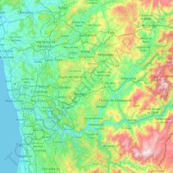
Name: Porto topographic map, elevation, terrain.
Location: Porto, Portugal (41.00138 -8.78906 41.47197 -7.87558)
Average elevation: 314 m
Minimum elevation: -2 m
Maximum elevation: 1,392 m
Thank you for supporting this site ❤️
Make a donation
Make a donation
Other topographic maps
Click on a map to view its topography, its elevation and its terrain.