
Thank you for supporting this site ❤️
Make a donation
Make a donation
Davao del Sur topographic map
Click on the map to display elevation.
Thank you for supporting this site ❤️
Make a donation
Make a donation
Davao del Sur
The province enjoys a mild, pleasant climate all year round. Because of its topographical characteristics and geographical location, it is rarely visited by typhoons. There is no pronounced wet or dry season. The coolest months are from November to February with an average temperature of 25 °C (77 °F). during the peak summer months from March to May, temperatures average 28 °C (82 °F) but may rise as high as 32 °C (90 °F).
Thank you for supporting this site ❤️
Make a donation
Make a donation
About this map
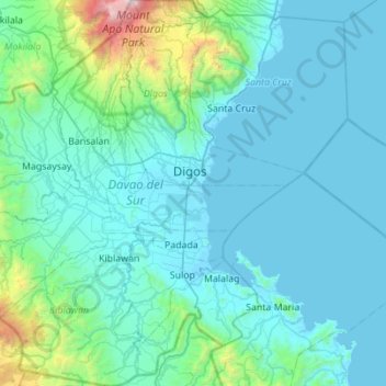
Name: Davao del Sur topographic map, elevation, terrain.
Location: Davao del Sur, Davao Region, Philippines (6.43538 125.05403 6.98719 125.61910)
Average elevation: 286 m
Minimum elevation: -5 m
Maximum elevation: 2,930 m
Thank you for supporting this site ❤️
Make a donation
Make a donation