
Thank you for supporting this site ❤️
Make a donation
Make a donation
Pará topographic map
Click on the map to display elevation.
Thank you for supporting this site ❤️
Make a donation
Make a donation
About this map
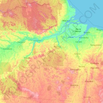
Name: Pará topographic map, elevation, terrain.
Location: Pará, North Region, Brazil (-9.83902 -58.89700 2.59093 -45.94340)
Average elevation: 176 m
Minimum elevation: -4 m
Maximum elevation: 800 m
Thank you for supporting this site ❤️
Make a donation
Make a donation
Other topographic maps
Click on a map to view its topography, its elevation and its terrain.
Atlantic Forest
Brazil > São Paulo > Região Metropolitana de São Paulo > Ribeirão Pires
Average elevation: 787 m