
Thank you for supporting this site ❤️
Make a donation
Make a donation
Tamworth topographic map
Click on the map to display elevation.
Thank you for supporting this site ❤️
Make a donation
Make a donation
About this map
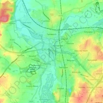
Name: Tamworth topographic map, elevation, terrain.
Location: Tamworth, Staffordshire, England, United Kingdom (52.58867 -1.73582 52.65750 -1.63293)
Average elevation: 76 m
Minimum elevation: 47 m
Maximum elevation: 130 m
Thank you for supporting this site ❤️
Make a donation
Make a donation
Other topographic maps
Click on a map to view its topography, its elevation and its terrain.