
Thank you for supporting this site ❤️
Make a donation
Make a donation
Saint Martin (France) topographic map
Click on the map to display elevation.
Thank you for supporting this site ❤️
Make a donation
Make a donation
About this map
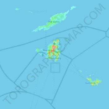
Name: Saint Martin (France) topographic map, elevation, terrain.
Location: Saint Martin (France), France (17.89635 -63.36056 18.19028 -62.76441)
Average elevation: 2 m
Minimum elevation: -2 m
Maximum elevation: 404 m
Thank you for supporting this site ❤️
Make a donation
Make a donation
Other topographic maps
Click on a map to view its topography, its elevation and its terrain.
Roche de Solutré
France > Bourgogne-Franche-Comté > Saône-et-Loire > Solutré-Pouilly
Average elevation: 371 m
Thank you for supporting this site ❤️
Make a donation
Make a donation
Le Moulin de Dore
France > Nouvelle-Aquitaine > Charente-Maritime > Barzan-Plage > Chez Pilou
Average elevation: 9 m
Thank you for supporting this site ❤️
Make a donation
Make a donation
Le Colombier
France > Nouvelle-Aquitaine > Corrèze > Lamazière-Basse > Le Colombier
Average elevation: 516 m
Île de Vassivière
France > Nouvelle-Aquitaine > Haute-Vienne > Beaumont-du-Lac
Average elevation: 664 m
Thank you for supporting this site ❤️
Make a donation
Make a donation