
Thank you for supporting this site ❤️
Make a donation
Make a donation
Laeken - Laken topographic map
Click on the map to display elevation.
Thank you for supporting this site ❤️
Make a donation
Make a donation
About this map
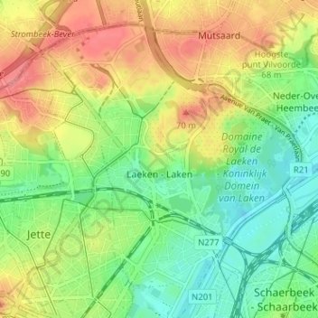
Name: Laeken - Laken topographic map, elevation, terrain.
Location: Laeken - Laken, Brussels, Brussels-Capital, 1020, Belgium (50.86827 4.31400 50.90242 4.37758)
Average elevation: 42 m
Minimum elevation: 10 m
Maximum elevation: 80 m
Thank you for supporting this site ❤️
Make a donation
Make a donation
Other topographic maps
Click on a map to view its topography, its elevation and its terrain.
Parc de Laeken - Park van Laken
Belgium > Brussels-Capital > Brussels > Laeken - Laken
Average elevation: 47 m