
Thank you for supporting this site ❤️
Make a donation
Make a donation
Almalaguês topographic map
Click on the map to display elevation.
Thank you for supporting this site ❤️
Make a donation
Make a donation
About this map
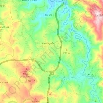
Name: Almalaguês topographic map, elevation, terrain.
Location: Almalaguês, Coimbra, Portugal (40.09892 -8.42258 40.16226 -8.35813)
Average elevation: 176 m
Minimum elevation: 28 m
Maximum elevation: 403 m
Thank you for supporting this site ❤️
Make a donation
Make a donation
Other topographic maps
Click on a map to view its topography, its elevation and its terrain.